

By: Shannon Mahre, Yakima Valley outdoor adventure guide*
Whether you’re looking for rugged, wide-open spaces or winding subalpine trails, you won’t find a shortage of scenic outdoor excursions all around the Yakima Valley. You don’t have to go far to experience the unique beauty of the valley’s shrub steppe landscape and surrounding mountain passes. Just a short drive takes you to any one of dozens of hikes on more than 200 miles of trails in the vicinity of the valley, from near the city of Yakima and the Yakima River Canyon to the White Pass Scenic Byway and Chinook Pass.
On your next visit to the Yakima Valley, plan an excursion to take one of these great hikes. If mountain biking is more your speed check out our Top Trails for Fall Mountain Biking.

1. Cowiche Canyon Conservancy Trails
- Location: West Yakima
- Length: 6.26 miles out and back (roundtrip mileage)
- Duration: 1 to 3 hours
- Multi-use trail for pedestrians, mountain bikers and horseback riders
- Best Season: Year-round depending on snowfall
Located in Cowiche Canyon, this hike was built on an old railroad bed and follows Cowiche Creek. Along this route, you’ll be surrounded by canyon walls made of andesite, rock columns made of basalt and a shrub steppe habitat that our area is proudly known for. While weaving through the canyon, you’ll cross a few bridges, as well as come across four connecting trails that lead up and out of the canyon. One of these trails, The Winery Trail, located on the north side of the Cowiche Canyon Trail, leads up to the vineyards and tasting room of the Wilridge Winery, Vineyard, and Distillery. The other three connecting trails link up with the Cowiche Canyon Uplands Trail System (which has a parking area off of Scenic Drive) and boasts more than 13 miles of trails that give beautiful, wide open views. It won’t be long until fall colors paint the canyon red, orange and yellow in October.
The trail can be accessed from the Cowiche Canyon East Trailhead on Cowiche Canyon Road or the Cowiche Canyon West Trailhead off of Weikel Road. Find all the trail maps and trailheads at the Cowiche Canyon Conservancy.
Check out Cycle Yakima for scenic ebike tours through the Canyon and surrounding areas, including brewery and winery stops.

2. Snow Mountain Ranch Trails
- Cowiche Mountain Trail West & Cowiche Mountain Trail East (link trails from parking area: Entry Trail & Riparian Trail East)
- Location: West of Yakima, WA
- Trail Difficulty: Easy (lower trails) to Intermediate
- Trail Features: Steady and sometimes steep uphill and downhill grade
- Length: 6.4-mile loop
- Duration: 4 to 6 hours
- For Hiking and Trail Running Only
- Best Season: Year-round depending on snowfall
Snow Mountain Ranch, also part of the Cowiche Canyon Conservancy, consists of 12 connecting marked trails from .1 miles to 2.7 miles in length. The trails at Snow Mountain Ranch vary from easy with mostly flat terrain to moderate with steep uphill grades, all lined with wildflowers in the spring that will absolutely take your breath away. The top of Cowiche Mountain is at an elevation 2970 feet, with spectacular views to the west of Mt. Adams, Mt. Rainier and the Oak Creek Wildlife Area as well as views to the east of the city of Yakima.
For the 6.4-mile loop, start with the Entry Trail (.2 miles) that begins at the parking area, then take the Riparian Trail East (1.3 miles), which has a mellow upward grade. At the Cowiche Mountain Trail East junction, take a right and begin your uphill ascent which will bring some rather amazing views. After two miles and just over 1,000 feet of hiking, you’ll come to a junction. To your left, the trail will take you to the Rocky Top Trail System and the top of Cowiche Mountain. To your right, the Cowiche Trail West will take you back down the mountain and after 2.7 miles will connect with the Entry Trail that leads to the parking area.
Snow Mountain Ranch is known locally and nationally for its plethora of native wildflowers in the spring months, especially from April to early June.
Find all the trail maps and trailheads at the Cowiche Canyon Conservancy.
Suggested Stops: After your hike or run, stop at The Cowiche Creek Brewing Company and relax over a Yakima Valley craft brew. They also have AMAZING burgers!

3. Boulder Cave
- Location: Highway 410 Chinook Pass
- Length: 2 miles loop (round trip mileage)
- Duration: 1 to 2 hours
- Elevation Gain: 300 feet
- Trail Difficulty: Easy
- Trail Features: Well-maintained trail – bring a headlamp for when you’re inside the cave.
- Best Season: Open May through October, Thursday through Sunday and holidays. Northwest Forest Pass or $5 vehicle fee required. Reservations are required to access the trail and the cave. Book them in advance up to two weeks prior to your visit.
Boulder Cave is more than 10 million years old and is worth an adventure. From the parking area, follow the trail, Sun and Sage loop, and keep a lookout for the signage that offers some historical facts about the area. The cave entrance is shaped like a tunnel and rather wide, so don’t worry about getting claustrophobic. Once you enter the cave, you’ll want to turn your headlamp on because it will get very dark. As this is a very important habitat for the pacific western big-eared bat, it is asked that guests only whisper while in the caves, to stay on the trail, to not touch the cave walls, and to keep your light on the trail (do not point it at the ceiling of the cave or the walls.)
After about 400 feet, you and your crew will emerge from the backside of the cave. Continue on the trail and you’ll make your way back to the parking area.
GPS: 46.9597, -121.0864
Suggested Stops: Hikes #4 through #8 above are on highway 12 White Pass or highway 410 Chinook Pass. Pick up some farm fresh fruit at McIlrath Family Farm Fruit Stand or Thompson’s Farm Market to take along. On the way back be sure to stop at Bron Yr Aur Brewing for a cold beverage and gourmet pizza.

4. Cleman Mountain (Water Works Canyon Trail Head)
- Location: West of Naches, WA
- Length: 6-mile loop (round trip mileage)
- Duration: 4 to 5 hours
- Elevation Gain: 2,000 ft
- Trail Difficulty: Moderate/Difficult
- Trail Features: Canyon – rocks and dirt with uphill trend. Ridgeline – steep, loose rocks, no-fall zones
- For Hiking and Trail Running Only
- Best Season: March through May and September through November; Discover Pass Required
Cleman Mountain is a pillar of the small town of Naches, WA, which is about 14 miles west of Yakima on Highway 12. There are a number of trails and routes for summiting Cleman Mountain, with some being more challenging and straight forward than others.
For the 6-mile loop, we suggest taking the counter-clockwise route, which leads you up the looker’s right ridge line which is steep, full of loose rocks and has a plethora of no-fall zones (coming down this way is not recommended). Along your hike, you’ll not only see views of the Naches Valley and beyond, but once you get high enough, you’ll be rewarded with 360-degree views of Mt. Adams, Goat Rocks, Mt Rainer and the Cascade Mountain Range.
To drop into Waterworks Canyon and close the loop for this hike, you’ll need to take the trail that sits in the saddle between “Point 3582” and Cleman Mountain (many people do a mini out-and-back hike to the top Cleman Mountain and then hike back down to the saddle to then take the trail into the canyon.) Keep in mind that there is some route-finding that may need to happen as there isn’t any signage on the ridge. Once you drop into Waterworks Canyon from “Point 3582”, the trail is very straightforward and packed in, with a mellow downward trend.
If the loop doesn’t sound like your cup of tea, you can always do an out and back in Waterworks Canyon as it is a moderate hike with mostly packed dirt, rocks and an uphill trend.
This is a great spring hike to view the wildflowers or in the fall for bright orange and red foliage as well as getting a glimpse of our local herd of bighorn sheep. The Waterworks Canyon Trailhead parking area is off of Highway 410, a few miles west of Naches, WA and requires a Discover Pass.
Suggested Stops: Post-hike, grab a coffee from Highway Espresso, a donut and bagel from Cot’s Peak in Naches or pizza and a beer from Bron Yr Aur Brewing Company. All of these spots are locally owned and are favorites for travelers and locals.
5. Naches Peak Loop (+2 Bonus Hikes!)
- Location: Highway 410, Chinook Pass
- Length: 3.5-mile loop (roundtrip mileage)
- Duration: 2 to 3 hours
- Elevation Gain: 659 ft
- Trail Difficulty: Intermediate/Moderate
- Trail Features: Packed dirt with rocks in areas – well-maintained
- Hiking and Trail Running Only
- Best Season: July through November; Northwest Forest Pass Required
Naches Peak Loop is a favorite for families and packs the most bang for your buck if you’re looking for a lot of beauty with low mileage. Located at Chinook Pass off Highway 410, take the log bridge that crosses the highway and follow the trail as it gently climbs through wildflower-filled meadows, views of Mt. Rainier and even a perfect picnic spot – you can’t miss the pond on your left with large rocks to sit on.
As you near the highest point of the trail (you’ll have a total ascent of around 659 ft), there are a few switchbacks that you should all be able to tackle with ease. At the top of the switchbacks, there will be a fork in the trail – take the trail on the right (the left fork is the Pacific Crest Trail, descending a mile to Dewey Lake 600 feet below). When you reach SR 410, hike along the highway back to your vehicle, or cross the road to Tipsoo Lake, another beautiful stop with a rest area, restrooms, picnic tables and a path that leads back to the log footbridge.
Where to Park: You have three choices for parking. The Tipsoo Lake Area parking lot is about .7 miles to the west and the Chinook Pass Overlook lot is about .7 miles east of the trailhead. The Chinook Pass Overlook lot will require a Northwest Forest Pass. You may also find parking along the highway.
GPS: 46.8674, -121.5176
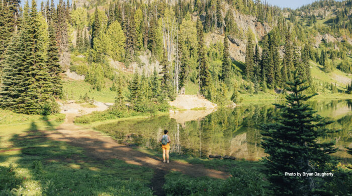
Tipsoo Lake (Bonus Hike #1)
Especially if you’ve parked at the Tipsoo Lake lot, the gentle walk around the perimeter of this picturesque lake is with the side stop. You can often catch the iconic reflection of Mt. Rainier in still waters.

Sheep Lake (Bonus Hike #2)
From the Chinook Pass Overlook lot, you’ll find the trailhead for a lovely, 3.6-mile, round-trip hike to Sheep Lake. This is an easy/moderate hike beginning an incline that traverses above highway 410 before turning to dip in and out of the trees before you emerge to this green gem of a lake. The elevation gain to this point is about 400 feet. From there, you can also choose to keep climbing to reach Sourdough Gap (making the round-trip hike a total of about 6 miles and 1,100 feet in elevation gain). Once you reach Sourdough Gap, you can view Sheep Lake below. On a clear day, you’ll be able to see Mount Rainier and the surrounding South Cascades, including Mount Adams and Mount St. Helens.

6. Umtanum Creek Canyon
- Location: Yakima River Canyon
- Length: 6.5 miles round trip
- Duration: 2 hours
- Elevation Gain: 500 ft
- Trail Difficulty: Easy to Intermediate/Moderate
- Trail Features: Packed dirt and rocks with some areas of tall grass and brush.
- Best Season: February through May; $5 Public Parking Fee
From the parking area, hop onto the suspension bridge that crosses the Yakima River. Take a moment during your crossing to look up and down river – there’s a high probability that you’ll see some anglers fishing this famous stretch of river.
After getting
off the bridge,
go under the railroad tracks
and follow the trail until
it splits into two.
The left trail will take you up to the ridge, and the right trail will take you
to the Umtanum Creek Canyon trail. After
taking the right trail, you will pass remnants of a homestead with heirloom
apple
trees, and you may even see some bighorn sheep, deer and elk that visit or live in the canyon. At the west end of the canyon, at about three miles and after a rocky section, the canyon narrows and trails are less defined, becoming difficult to find your way. This is a great place to turn around – or choose to continue if you’re in for a bit of an adventure.
Springtime on this trail brings beautiful wildflower-covered hillsides and the fall will highlight the foliage in those bright reds and oranges and yellows that we all love.
The Umtanum Creek Recreation Area is a BLM managed campground with access to the Yakima River.
GPS: 46.8554, -120.4833

7. Ahtanum Ridge
- Location: Union Gap, WA
- Length: 2.5-mile loop (roundtrip mileage)
- Duration: 1.5 to 3 hours
- Elevation Gain: 885 ft
- Trail Difficulty: Intermediate/Moderate
- Trail Features: Versatile with some steep and sometimes slippery sections
- Best Season: Year-round depending on snowfall
This high desert trail is lined with sagebrush, tall grass and wildflowers in the spring. A short, steep climb to the top of the ridge will reward you with spectacular views of the lower valley, Mt. Adams and Mt. Rainer, as well as Union Gap and Yakima. And for those farm equipment and history buffs, the view from the top also showcases more than 100 antique tractors and other machinery at the Central WA Agricultural Museum.
The Ahtanum Ridge trail starts near the museum entrance at Fulbright Park, left of the tank display. This is a very steep climb until ¾ of the way to the top of the ridge, with a total elevation gain 885 feet. The descent has more switchbacks than the ascent, making it a more gradual and safer way to finish up your hike.
Suggested Stops: Take time to walk through the Central Washington Agriculture Museum and view the acres of artifacts from the history of farming in the Valley. Stop at Los Hernandez Tamales in Union Gap, WA, for their James Beard award winning tamales.
8. Selah Cliffs Natural Area Preserve
- Location: Yakima River Canyon
- Length: 2.5 miles, round trip
- Duration: 1 to 2 hours
- Elevation Gain: 102 feet
- Trail Difficulty: Easy
- Trail Features: Packed dirt and rocks
- Best Season: May through October
The Selah Cliffs Natural Area Preserve trail features a half-mile interpretive loop, as well as a two-mile out-and-back trail which offers closer views of the Fred G.Redmon Bridge and the large basalt cliffs and areas of shrub-steppe habitat along Selah Creek. The cliffs in this preserve are a nesting habitat for prairie falcons, red-tailed hawks and kestrels, so keep an eye out for some stellar bird watching. This is a great beginner hike and is family-friendly, but as with other hikes in this desert environment, be aware that we are sharing these habitats with snakes and other animals. Simply be watchful.
Established in 1993, this preserve protects the basalt daisy, a state-listed threatened species, along a 10-mile section of the Yakima River Canyon. The basalt daisy roots in cracks and fissures on the rock faces of basalt cliffs and blooms May through October, peaking in June.
Dogs are not allowed on this preserve.
GPS: 46.7090, -120.4666

9. Round Mountain
- Location: Highway 12 White Pass.
- Length: 5.4-mile loop (round trip mileage)
- Duration: 3 to 4 hours
- Elevation gain: 1,700 ft
- Trail Difficulty: Moderate to Hard
- Trail Features: Mostly packed dirt with some rocks.
- Hiking and Trail Running Only
- Best Season: July through September; Northwest Forest Pass Required.
This hike winds its way through forested terrain in the Goat Rocks Wilderness, with switchbacks and a pretty consistent steep upward trend. With 1,700 feet of climbing in under three miles, you’ll do a bit of work to earn the epic views from the summit.
On a clear day, you’ll not only see Rimrock Lake and Clear Lake below, but also views of Bear Creek Mountain, Tieton Peak and Mount Adams.
Near the top, you’ll hit a junction with the Pacific Crest Trail, making this a fun side trip while hiking the PCT.
GPS: 46.6344, -121.3033

10. Tieton Nature Trail
***Trail Notice: Due to a 2024 wildfire, the landscape along this trail is still recovering. Please recreate responsibly and treat it with care! Be sure to stay on the trail.
- Location: Naches, WA, off Highway 12 (White Pass)
- Length: 8 miles out and back (round trip mileage)
- Duration: 3 hours
- Elevation Gain: 300 ft
- Trail Difficulty: Easy
- Trail Features: Packed dirt, some rocks, family friendly
- Multi-Use Trail for pedestrians, mountain bikers and horseback riders
- Best Season: March through December
The Tieton River Nature Trail has almost everything you would ever want in a mellow hiking or biking trail. With an elevation of 300 feet, the trail follows a very slight upward trend as it follows the Tieton River up the canyon. From the Royal Columns, dramatic cliffs of columnar andesite that welcome you as you begin your hike (you may see some climbers on them!), to the oak trees, aspens, willows, wildflowers and sage brush that will showcase their beauty around every turn, you’ll quickly realize why this trail is a favorite for locals.
The parking area is at milepost 183.5 on highway 12 across from the Oak Creek Wildlife Area. The trail is reached by walking across the bridge turning right and passing through the gate in the elk fence. After less than two miles, there is a suspension bridge, leading to a second parking option near an old quonset hut. Continuing on the trail you’ll reach the third bridge, which has no railings and is made out of old apple bins. There are small parking areas at the suspension bridge and at the third bridge, offering multiple ways that you can access the trail.
The wildflowers are best here a bit later in the spring
than Yakima Valley
proper and in the fall, the
contrast of the rock and fall colors are truly a sight to see.
GPS: 46.7192, -120.8344
Most photos by Shannon Mahre
Categorized in: Family Fun, Featured, Outdoor Recreation, Summer